BANFF – Parks Canada is ramping up plans for logging and prescribed fire work to reduce the risk of a catastrophic wildfire to the Banff townsite following decades of fire suppression in surrounding forests throughout the national park.
Much of the work is already underway, with more in the coming year or two, which Parks Canada officials say is on top of 7,000 hectares of logging, thinning and prescribed burns already completed over the past 10 years in Banff National Park and almost 15,000 ha over the past 15-year period.
“We have a really busy program here; we are one of the programs that has done the most in the past 10 to 20 years,” said Jane Park, fire and vegetation management specialist for Banff National Park during a presentation to Banff town council Monday (Feb. 10).
“We’re trying to mitigate risk from every angle.”
Recent unprecedented wildfire seasons in Canada, including the devastating wildfire that destroyed one-third of housing in the Jasper townsite last summer, have stoked the fears of residents of Banff, a community surrounded by dense forests.
As the climate changes, fire seasons are predicted to become longer, with wildfires becoming larger and burning more severely, and fire managers in many jurisdictions are looking at and reassessing how to best manage the increasing risk.
Coun. Grant Canning said he valued the work Parks Canada is doing to help protect Banff.
“We all know this topic is very top of mind for residents and there’s a lot of concern out there,” he said.
Prescribed fires on books
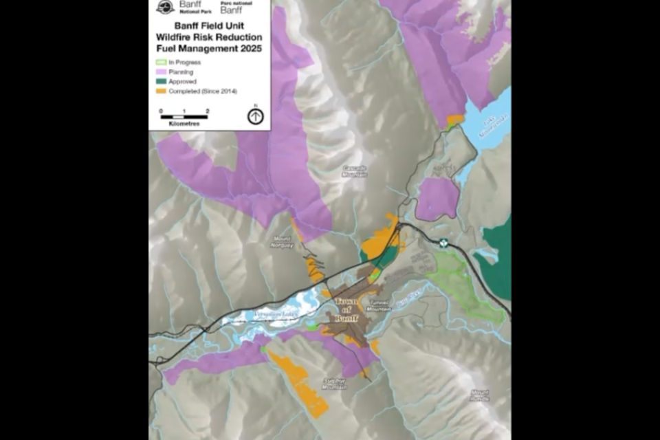
About 1,579 hectares of planned work, primarily through logging, includes 347 ha in the Brewster-Healy creeks area, 210 ha in the Spray River Valley, 83 ha in Middle Springs, 274 ha at Bumpy Meadows south of Two Jack campground and 665 ha in the lower Cascade Valley near Lake Minnewanka.
Five approved prescribed fires are also on the books, including 4,711 ha on the Fairholme benchlands on the north side of the Trans-Canada Highway between Banff and Canmore, which was last burned in 2003.
In addition, there are plans for a 64-ha burn to finish off the Compound Meadows immediately north of the townsite, 880 ha at Wigmore Meadows in the Cascade Valley, 117 ha at Red Deer Meadows in the Upper Red Deer Valley, and 210 ha at Flint’s Meadows in the middle Cascade Valley.
“How it works with prescribed fires, is we tend to have more prescribed fires approved than we actually try to implement,” Park said.
“That allows us to have a variety of prescription windows that we can have to try to do some of the burns.”
Even though some of these prescribed fires are in the remote backcountry away from the Banff townsite, Park said they play a very important role in terms of landscape resiliency to things like climate change and wildfires.
“The longer distance you have without any mitigations, without any break in fuel, the more steam a wildfire can have, so the more we break up the landscape at a larger level, even outside of the town, the better it is in terms of resilience to wildfire,” she said.
“You can imagine that if a fire started way up the Cascade Valley – and we have a series of prescribed fires we’ve done back there – they have less of a chance to make it all the way to town … we’re trying to break that up both locally close to the community as well as far away in the backcountry as well.”
Mitigation in Banff townsite
Parks Canada is currently logging an area known as the Tunnel Toe on Tunnel Mountain, which aims to help protect communities down valley like Canmore, but could help Banff fight an advancing wildfire if it were to come from the east.
Park said more than 70 ha is being logged this winter and the remaining 141 ha will be completed over next fall and winter, which when completed, will be slightly bigger than the Lake Louise fireguard and the guard on the west side of Sulphur Mountain.
“To be honest, this one does help more if a fire were to come into the Bow Valley and then start to turn that corner to head further down the valley, but we do sometimes get upwind or upslope conditions as well that can blow fires the opposite way as well,” she said.
Crews have also been working in Middle Springs, Valleyview as well as on the Cascade-Minnewanka fireguard.
“That is a bigger guard that was put in several years ago, mechanically, but because the vegetation has been growing up, the crews are in there cleaning that up,” she said.
“That assists with fire that may come down Cascade Valley towards the town of Banff and the Bow Valley.”
Planned work in the Healy-Brewster area, which will extend from Sunshine Village Road to Sundance Canyon, aims to enhance wildfire risk reduction project work that was done on Sulphur Mountain.
“That will assist us if a fire comes down the Bow Valley toward town,” said Park.
“We’re in the process of doing some engineering assessments and getting some timber cruising (an inventory of the forest stand) done this winter.”
Park also pointed to logging and thinning work previously done around Middle Springs and in the Spray Valley.
“There’s a series of previously mechanically logged and hand-felled areas that we will tie together into a larger unit and that will protect the town from the south,” she said.
“We will be tendering some timber cruising of that area so we can start implementing it along with the Brewster-Healy unit next year.”
Logging and thinning work is also planned for an area south of Two Jack Campground known as Bumpy Meadows.
“Again, if a fire were to come out of the Cascade Valley and try to come into the Bow Valley from the north, that does help that,” Park said.
“We’ve got a prescribed fire, that is still kind of conceptual, that we’re applying that’s up 40 Mile Creek area that also will help the town if anything comes from the north.”
In addition, the Sawback Range region along the Bow Valley Parkway west of the Banff townsite has been burned several times since the 1990s and a fireguard near Protection Mountain also helps to slow the spread of fire advancing from the west.
“Some of those projects will also obviously help in the event of a wildfire coming down the Bow Valley from the west,” Park said.
Parks Canada has 88 vegetation and forest monitoring plots across the landscape for completed and planned areas that help with decision-making to prioritize and plan wildfire risk reduction projects.
Specific thresholds from scientific evidence of fire behaviour are used to guide maintenance activities.
“We measure everything from what kind of trees are coming up to how much course woody debris, so logs and snags, how much grass, how many shrubs have grown up,” Park said.
Park said a fireguard that had been previously logged and burned at Carrot Creek adjacent to Harvie Heights helped with a lightning-strike fire last summer.
“We did have a lightning start in August when there were already multiple fires in the area, down in Kootenay, but because it started in the area that had been previously logged and burned, fire crews were able to catch that within a day,” she said.
Park said the fireguard on the west side of Sulphur Mountain, an area she said went from heavily treed to a thriving grassland – is another good example.
“Eventually we may do some prescribed fire, but again, if a fire starts there it’s much easier to suppress than had it been a fully timbered area,” she said.
Modelling to predict wildfire threats
Banff National Park works closely with other organizations like Natural Resources Canada and Canadian Forest Service, as well scientists at the University of Alberta to look at burn probability and wildfire hazard, wildfire exposure assessments, and climate change impacts to wildfire risk and fuels.
“Using the most up-to-date fire prediction modelling, to looking where fires may spread, to also trying to model the probability of a fire actually starting, and then how intense that fire may be if it does start,” Park said.
“We’re also looking at the best configuration of treatments across the landscape to lower the wildfire risk to the community.
There is also a LiDAR vegetation mapping project with the University of Lethbridge.
“We’ve obtained really high resolution LiDAR vegetation mapping of most of the park and especially in the Bow Valley so we can have really refined models and mapping of our fuel loads,” Park said.
“That really helps us with a lot of planning for wildfire risk reduction projects as well.”
Park said wildfire risk modelling based on future climate change scenarios is also underway this winter.
“They are looking at 10-, 20-, 30-year projections of both climate change and changes in vegetation that may come because it gets hotter and drier or cooler and wetter and how that’s going to change the wildfire risk to the community,” she said.
A changing climate may also have impacts on when prescribed fires can be done.
Prescribed fires are typically only lit during a small window as it is, but Park said that is something that will have to be looked at as climate change potentially makes these windows even shorter and wildfire seasons are getting busier.
“We have to try to figure out how we can still do and use all these tools in a way that benefits the landscape and that we maximize these opportunities,” she said.
One example of that is potentially breaking the large-scale Fairholme prescribed burn into smaller pieces as opposed to one big burn, which was done in 2003.
“Maybe we do a bit more mechanical treatments around the edges so we have a higher probability of actually being able to mitigate that fuel load as opposed to 20 years ago they did all of that in one summer,” she said.
“I don’t know that now we have those climatic conditions that that is a real expectation and so we are starting to look at innovative ways to do things. We’re working closely with a lot of local Indigenous Nations trying to see what the interest and capacity is for cultural fire as a tool.”
Canning said he didn’t realize all the work Parks Canada was doing with researchers and scientists at the University of Alberta and University of Lethbridge, but it prompted questions about the effectiveness of modelling.
“From your experience from looking back at Jasper and Waterton, how effective is modelling? Has the modelling been pretty effective at predicting?” he said.
Park said they are, but noted all models have limitations because they usually draw from a subset of data from the past. Recent fire conditions and behaviour in an accelerated changing climate were not seen in the past.
“A lot of models don’t predict quite like the types of fire behaviour we’re seeing in the last five to 10 years … it’s hotter, it’s drier, there’s more fuel on the landscape, and what we’re finding is that the models are not predicting that extreme fire behaviour because we’re never seen it before,” she said.
“That being said, we know as fire practitioners that we are on that outside edge of things now, so when we look at the models, we have to squint at it, and we do want to make sure we are erring on the cautious side, but largely they are very helpful.”
Coun. Barb Pelham raised the issue of evacuation in the event of a wildfire.
“Healy Creek and Sunshine Road, if it’s being treated as a fireguard, could it also be a route for exit from the town if needed,” she said.
Park said that idea is being explored.
“There is a river between where cars can currently go and where cars can currently not go, and so part of the planning is to do an engineering assessment to see what the potential is for something like that,” she said.
“Obviously, there are a lot of legislative and policy processes that have to go through but we are looking into that, and actually have a tender out right now for that.”
• A public panel discussion will held by the newly formed Bow Valley Interagency Wildfire Committee at Banff Town Hall on Tuesday, Feb. 25, from 6:30-8 p.m. Following the panel, there will be an opportunity for questions. A live stream and recording will be available.


