A fatal plane crash in Kananaskis that killed six people last summer was likely caused by poor weather conditions and the pilot’s decision to continue flying despite encountering reduced visibility, an investigative report found.
The Transportation Safety Board (TSB) says weather near the crash site on Mount McGillivray, south of the Lac Des Arcs townsite, indicated clouds were “likely low.”
“From the data collected through the investigation, the pilot did not obtain a weather briefing from a NAV Canada specialist,” said Chris Krepski, TSB media relations specialist, in an email.
“As stated in the [investigation] report, pilots are encouraged to obtain a weather briefing from a NAV Canada specialist to assist in acquiring a thorough and complete understanding of the current and forecast weather along a planned flight route.”
The report, released Wednesday (Oct. 2) notes the pilot instead sought weather forecast information from an internet source and discussed conditions with an individual at the Springbank Airport before departing.
“When the pilot encountered clouds and reduced visibility, for unknown reasons, he decided to continue the flight toward the destination, and, subsequently, the aircraft collided with terrain in the cruise attitude,” states the safety board’s report.
It further notes the pilot’s decision to make the flight “was influenced by an incomplete understanding of the weather, familiarity with the route, time pressure, and a personal desire to complete the flight.”
Weather reported at the airport that day had been “variable.” En-route weather was described as overcast at 4,000-6,000 feet, with visibility varying from light rain showers, mist and clouds along the foothills.
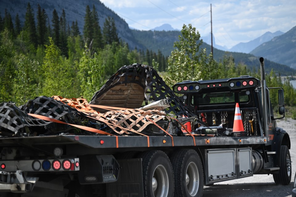
The privately owned single-engine Piper PA-32R departed the Springbank Airport around 8:30 p.m. on July 28, 2023, with the pilot and five passengers onboard en-route to Salmon Arm, B.C. for a church function.
“At approximately 2057 [8:57 p.m.], radar contact with the aircraft was lost owing to the rising terrain approximately 17.5 nautical miles (NM) west of [the airport],” states the report. “The aircraft’s last recorded altitude and ground speed, approximately 50 seconds earlier, were 5,800 feet ASL [above sea level] and 150 knots, respectively.”
The aircraft crashed into a mountain about 15 minutes into the flight, according to the TSB. It was subsequently destroyed, fatally injuring all onboard. The plane also caught on fire after flying into the mountain.
The party was reported overdue to RCMP at about 1 a.m. on July 29, prompting a search.
The Joint Rescue Coordination Centre assigned the Royal Canadian Armed Forces (RCAF) CC-130H Hercules from the 435 Transport and Rescue Squadron for the search. The aircraft’s emergency locator transmitter led the team to the crash site on the east slope of Mount McGillivray.
Kananaskis Mountain Rescue, Alpine Helicopters, Alberta Health Services EMS and an RCAF CH-149 Cormorant from the 442 Transport and Rescue Squadron were also dispatched to assist.
Krepski noted pilots are encouraged to obtain as much weather information possible prior to departing on a flight and be willing to alter a flight plan should the need arise.
The TSB’s report noted the pilot’s training and practice hours may have also played a part in the crash.
“If pilots don’t practice instrument flying skills regularly, there is a risk that they may not be able to maintain aircraft control and navigate accurately should they inadvertently encounter weather conditions requiring reference to their instruments,” it states.
“Also, if pilots do not complete mountain flying training, there is a risk that they will not be adequately prepared for the conditions encountered when flying over mountainous terrain.”
Garry Wutzke, a pilot with the Calgary Civil Air Search and Rescue Association has been flying for 65 years and has experience flying in mountainous terrain.
“The trouble is, with flying west, the terrain rises,” he said. “So, if you've got a low cloud, you're narrowing that gap and the terrain just rises in front of you. To me, it sounds like the pilot didn't see what he hit.
“Weather is just a small inconvenience. It’s unfortunate that so many people had to die from this.”
All six occupants of the plane were pronounced dead on site. The TSB’s investigation examined the wreckage site, interviewed witnesses and sent pieces of the aircraft to its engineering lab in Ottawa for analysis.
The plane’s occupants were identified in the weeks following as brothers Braydon and Benjamin Ryan, as well as Kirk Mealey, Adam Laser, Jacob Brown and Luke MacKelvie. All were residents of Calgary and involved in the church community through Harvest Hills Alliance Church and RockPointe Church.
The Local Journalism Initiative is funded by the Government of Canada. The position covers Îyârhe (Stoney) Nakoda First Nation and Kananaskis Country.


