ST. PAUL - On Sept. 9, during the Town of St. Paul’s regular council meeting, council members discussed an issue that may influence the improvement of Highway 28 - and future transportation investment decisions in northeast Alberta.
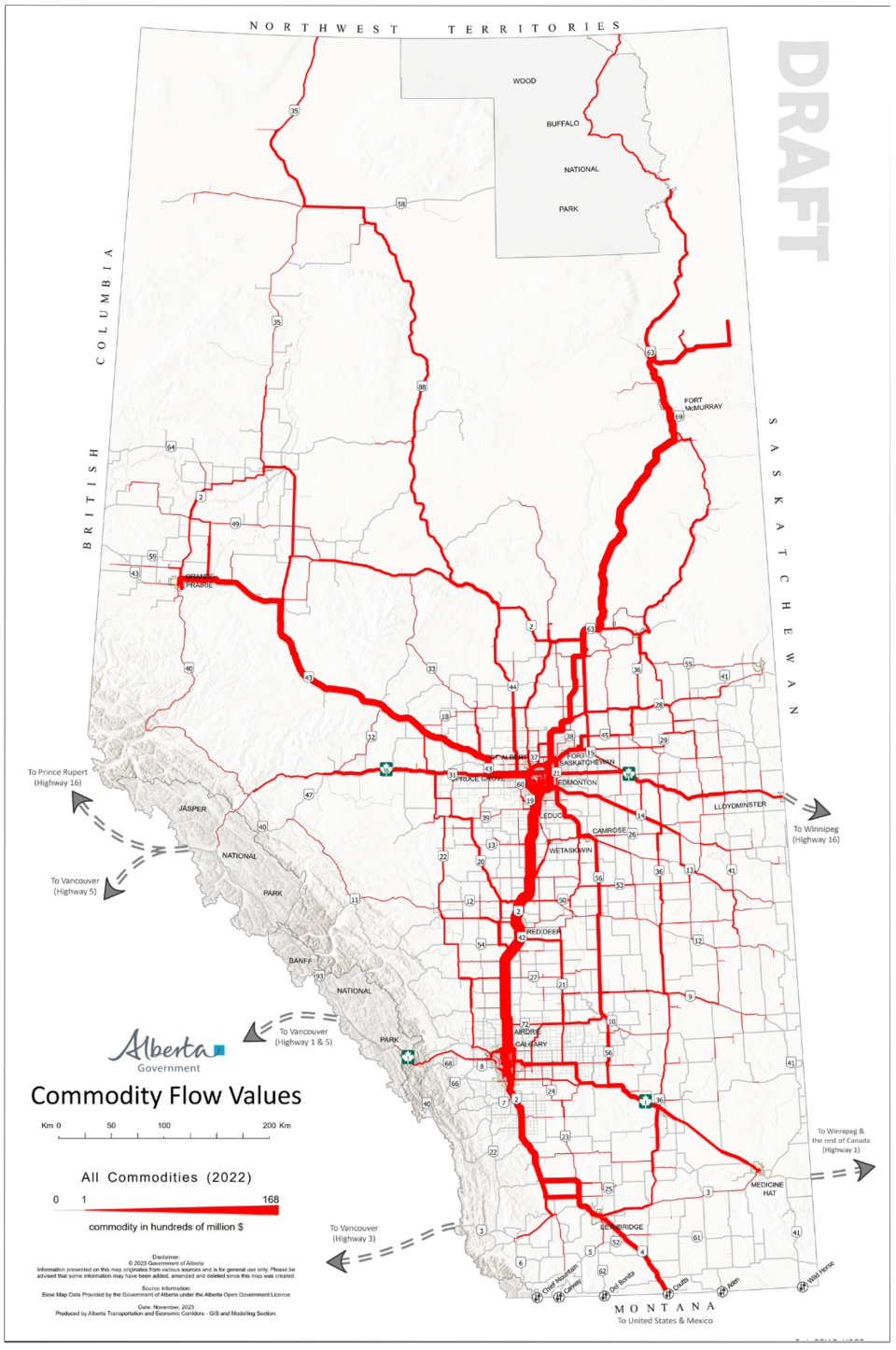
The Town received a letter from Bonnyville-Cold Lake-St. Paul MLA Scott Cyr, who explained that the Alberta Transportation and Economic Corridors (ATEC) is creating a resource mapping system to assess the value of commodities being transported on Alberta’s major highways – called the Commodity Flow Values Map.
“The results of this initiative will likely influence future transportation investment decisions, and ATEC is offering municipalities the opportunity to ensure they are accurately represented in this work,” noted Cyr.
In the letter, Cyr said that he found “inaccuracies” in the draft map, and that the economic activity along Highway 28 “is significantly underrepresented.” He said the
section of Highway 28 on the map, which services St. Paul and other Lakeland municipalities, is shown to contribute less to the province’s economy than what he believes it should.
“The line in the graphic should be at least as thick as the one for Grande Prairie, given that our region generates a comparable level of economic output,” said Cyr.
Cyr added that Highway 55, another key transportation artery in the region, also seems to be inaccurately depicted.
“It appears that ATEC may not have taken all the necessary data for our region into account,” he said, before urging Town council to review the map and contact ATEC to ensure accurate reflection of the region’s commodity data.
The MLA also said that while the region may not have the same population as Grande Prairie, “Our region punches well above its weight in terms of economic activity,” and deserves an accurate representation of that.
“We are not looking to be confrontational. We just want to ensure that our region is accurately represented, and we hope this feedback is taken in the spirit of collaboration,” said Cyr.
Council agrees
CAO Steven Jeffery, while presenting Cyr’s letter to council, said he agrees that “Our highways seem significantly underrepresented compared to other areas of the province.”
Mayor Maureen Miller said that when she previously met with Alberta Minister of Transportation and Economic Corridors Devin Dreeshen, “He alluded to the fact that we were going to start doing construction of highways based on the economic driver” of a region.
“Knowing the facts that come out of the northeast here . . . I challenge where they came up with this information,” said Miller.
Coun. Nathan Taylor also questioned if the map considers other means of transporting commodities aside from road use. If the map only reflects road-use, it will not accurately reflect the economic activity in the region.
Miller concurred. “This definitely needs to be reviewed,” she said, suggesting the Town speak to Cyr and other municipal councils in the region.
Jeffery said collaboration was crucial, “rather than being stuck in our own little jurisdictions.”
Following more discussions, Coun. Gary Ward made a motion for council to direct administration to write a letter back to Cyr for further information, and to request to speak with him and other regional municipalities in northeast Alberta during a meeting to take place at the Alberta Municipalities Fall Conference.


